Geolocate

Norman topographic map

Click on the map to display elevation.

About this map

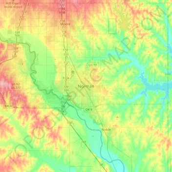
Name: Norman topographic map, elevation, terrain.

Location: Norman, Cleveland County, Oklahoma, 73069, United States (35.06257 -97.59948 35.38257 -97.27948)

Average elevation: 1,168 ft

Minimum elevation: 1,040 ft

Maximum elevation: 1,365 ft

Cleveland County trails, hiking, mountain biking, running and outdoor activities

Gear up for your next adventure:

🎒Trekking Poles - Sturdy poles for balance and stability on rough terrain
🚗GPS Dash Cams - Record your scenic drives through mountain passes and canyons
🎒Hydration Pack - Hands‑free water reservoir for long hikes
🌐World Map Poster - Decorative world maps with topographic info
🔦LED Headlamp - Bright and durable LED headlamp for night navigation

As an Amazon Associate, this site earns from qualifying purchases at no extra cost to you.