Geolocate

Lousame topographic map

Click on the map to display elevation.

About this map
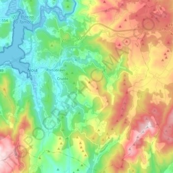
Name: Lousame topographic map, elevation, terrain.

Location: Lousame, Noia, A Coruña, Galicia, Spain (42.71246 -8.92870 42.83426 -8.76550)

Average elevation: 840 ft

Minimum elevation: -16 ft

Maximum elevation: 2,185 ft

Other topographic maps

Click on a map to view its topography, its elevation and its terrain.

Crons

Spain > Galicia > Noia

Average elevation: 538 ft

Campo Lameiro

Spain > Galicia > Noia > Portobravo > Pastoriza

Average elevation: 420 ft

Cuns

Spain > Galicia > Noia

Average elevation: 669 ft

Froxán

Spain > Galicia > Noia

Average elevation: 1,093 ft

O Castro

Spain > Galicia > Noia > O Porto do Son

Average elevation: 262 ft

O Lapido

Spain > Galicia > Noia > Porto do Son

Average elevation: 213 ft

Gear up for your next adventure:

📖Nature Tracking Books - Learn to track wildlife and terrain
🥩Freeze-Dried Meals - Nutritious and lightweight food for remote expeditions
🔥Plasma Lighters - Windproof lighters that work in any weather condition
🦟Ultrasonic Repellers - Create a bug-free zone at your camp or rest stop
📡GPS Antenna Upgrade - Enhance GPS reception in remote terrain

As an Amazon Associate, this site earns from qualifying purchases at no extra cost to you.