
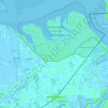
Nieuw Namen topographic map
Interactive map
Click on the map to display elevation.
About this map
Name: Nieuw Namen topographic map, elevation, terrain.
Location: Nieuw Namen, Hulst, Zeeland, Nederland (51.28235 4.10937 51.38756 4.23681)
Average elevation: 3 ft
Minimum elevation: -13 ft
Maximum elevation: 30 ft
Other topographic maps
Click on a map to view its topography, its elevation and its terrain.
Emmadorp
Nederland > Zeeland > Nieuw Namen
Emmadorp, Nieuw Namen, Hulst, Zeeland, Nederland, 4568 PS, Nederland
Average elevation: 3 ft
Verdronken Land van Saeftinghe
Nederland > Zeeland > Nieuw Namen
Verdronken Land van Saeftinghe, Nieuw Namen, Hulst, Zeeland, Nederland, 4568 PW, Nederland
Average elevation: 3 ft