
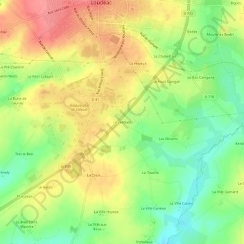
Le Terduez topographic map
Interactive map
Click on the map to display elevation.
About this map
Name: Le Terduez topographic map, elevation, terrain.
Average elevation: 433 ft
Minimum elevation: 299 ft
Maximum elevation: 561 ft
Other topographic maps
Click on a map to view its topography, its elevation and its terrain.
Le Haut Breuil
France > Bretagne > Côtes-d'Armor > Loudéac
Le Haut Breuil, Loudéac, Saint-Brieuc, Côtes-d'Armor, Bretagne, France métropolitaine, 22600, France
Average elevation: 492 ft
Le Petit Calouët
France > Bretagne > Côtes-d'Armor > Loudéac
Le Petit Calouët, Loudéac, Saint-Brieuc, Côtes-d'Armor, Bretagne, France métropolitaine, 22600, France
Average elevation: 449 ft
La Ville Léon
France > Bretagne > Côtes-d'Armor > Loudéac > La Ville Léon
La Ville Léon, Loudéac, Saint-Brieuc, Côtes-d'Armor, Bretagne, France métropolitaine, 22600, France
Average elevation: 413 ft