
Achintee topographic map
Interactive map
Click on the map to display elevation.
About this map
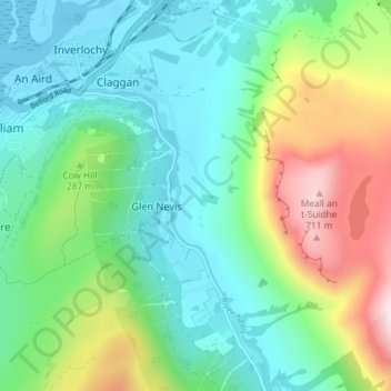
Name: Achintee topographic map, elevation, terrain.
Location: Achintee, Glen Nevis, Highland, Écosse, PH33 6TE, Royaume-Uni (56.79092 -5.09250 56.83092 -5.05250)
Average elevation: 702 ft
Minimum elevation: -3 ft
Maximum elevation: 2,454 ft
Other topographic maps
Click on a map to view its topography, its elevation and its terrain.
Glen Nevis
Royaume-Uni > Écosse > Highland > Glen Nevis
Glen Nevis, Highland, Écosse, PH33 6PF, Royaume-Uni
Average elevation: 584 ft