
Make a donation
Gear up for your next adventure:
As an Amazon Associate, this site earns from qualifying purchases at no extra cost to you.
Durango topographic map
Click on the map to display elevation.
Make a donation
Gear up for your next adventure:
As an Amazon Associate, this site earns from qualifying purchases at no extra cost to you.
Durango
Durango (Spanish pronunciation: [duˈɾaŋɡo], Southeastern Tepehuan: Korian) is the capital and largest city of the northern Mexican state of Durango and the seat of the Durango municipality. It has a population of 654,876 as of the 2015 census. The city's official name is Victoria de Durango, Victoria having been added in honor of the first president of Mexico, Guadalupe Victoria, who hailed from the state of Durango. The city is located in the Valley of Guadiana and sits at an altitude of 1,890 m (6,201 ft).
Make a donation
Gear up for your next adventure:
As an Amazon Associate, this site earns from qualifying purchases at no extra cost to you.
About this map
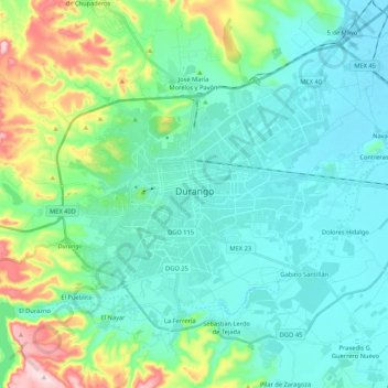
Name: Durango topographic map, elevation, terrain.
Location: Durango, Municipio de Durango, Durango, Mexico (23.94563 -104.73078 24.09514 -104.51793)
Average elevation: 6,352 ft
Minimum elevation: 6,102 ft
Maximum elevation: 7,300 ft
Make a donation
Gear up for your next adventure:
As an Amazon Associate, this site earns from qualifying purchases at no extra cost to you.
Other topographic maps
Click on a map to view its topography, its elevation and its terrain.