
Turrella topographic map
Interactive map
Click on the map to display elevation.
About this map
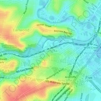
Name: Turrella topographic map, elevation, terrain.
Average elevation: 66 ft
Minimum elevation: -10 ft
Maximum elevation: 184 ft
Other topographic maps
Click on a map to view its topography, its elevation and its terrain.
Mascot
Australia > New South Wales > Bayside Council > Sydney
Mascot, Sydney, Bayside Council, New South Wales, 2020, Australia
Average elevation: 26 ft
Botany Bay
Australia > New South Wales > Bayside Council > Sydney
Botany Bay, Sutherland Shire, Sydney, Sutherland Shire Council, Bayside Council, New South Wales, Australia
Average elevation: 26 ft
Rockdale
Australia > New South Wales > Bayside Council > Sydney
Rockdale, St George, Sydney, Bayside Council, New South Wales, 2216, Australia
Average elevation: 66 ft