
Thank you for supporting this site ❤️
Make a donation
Make a donation
Gear up for your next adventure:
As an Amazon Associate, this site earns from qualifying purchases at no extra cost to you.
Kronplatz - Plan de Corones topographic map
Click on the map to display elevation.
Thank you for supporting this site ❤️
Make a donation
Make a donation
Gear up for your next adventure:
As an Amazon Associate, this site earns from qualifying purchases at no extra cost to you.
Kronplatz - Plan de Corones
The Kronplatz (Ladin and Italian: Plan de Corones) is a mountain of the Dolomites in South Tyrol, northern Italy, with a summit elevation of 2,275 metres (7,464 ft) above sea level.
Thank you for supporting this site ❤️
Make a donation
Make a donation
Gear up for your next adventure:
As an Amazon Associate, this site earns from qualifying purchases at no extra cost to you.
About this map
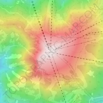
Name: Kronplatz - Plan de Corones topographic map, elevation, terrain.
Average elevation: 6,407 ft
Minimum elevation: 5,174 ft
Maximum elevation: 7,457 ft
Thank you for supporting this site ❤️
Make a donation
Make a donation
Gear up for your next adventure:
As an Amazon Associate, this site earns from qualifying purchases at no extra cost to you.