
Haltwhistle topographic map
Interactive map
Click on the map to display elevation.
About this map
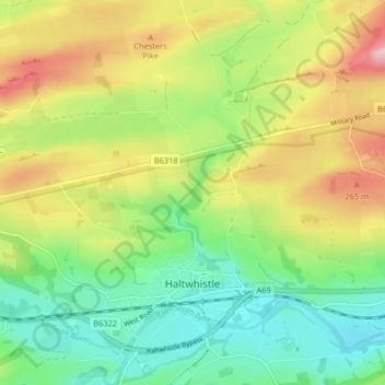
Name: Haltwhistle topographic map, elevation, terrain.
Average elevation: 594 ft
Minimum elevation: 312 ft
Maximum elevation: 1,024 ft
Other topographic maps
Click on a map to view its topography, its elevation and its terrain.
Lindisfarne
Royaume-Uni > Angleterre > Northumberland > Holy Island
Lindisfarne, Holy Island, Northumberland, North of Tyne, Angleterre, Royaume-Uni
Average elevation: 3 ft
Corbridge
Royaume-Uni > Angleterre > Northumberland
Corbridge, Northumberland, North of Tyne, Angleterre, Royaume-Uni
Average elevation: 420 ft