
Glotzdorf topographic map
Interactive map
Click on the map to display elevation.
About this map
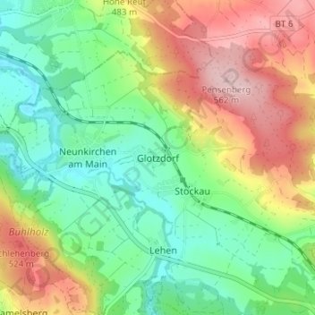
Name: Glotzdorf topographic map, elevation, terrain.
Average elevation: 1,434 ft
Minimum elevation: 1,155 ft
Maximum elevation: 1,850 ft
Das Dorf liegt ca. 5 km südöstlich von Bayreuth im Tal der Ölschnitz am Fuß der Anhöhe Pensen.
Other topographic maps
Click on a map to view its topography, its elevation and its terrain.
Neunkirchen am Main
Deutschland > Bayern > Landkreis Bayreuth > Weidenberg > Neunkirchen am Main
Neunkirchen am Main, Weidenberg, Weidenberg (VGem), Landkreis Bayreuth, Bayern, 95517, Deutschland
Average elevation: 1,375 ft
Heßlach
Deutschland > Bayern > Landkreis Bayreuth > Weidenberg > Heßlach
Heßlach, Weidenberg, Weidenberg (VGem), Landkreis Bayreuth, Bayern, 95466, Deutschland
Average elevation: 1,765 ft