
Municipality of Mykonos topographic map
Interactive map
Click on the map to display elevation.
About this map
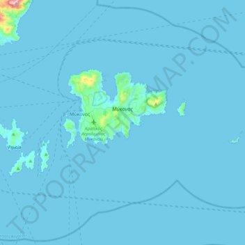
Name: Municipality of Mykonos topographic map, elevation, terrain.
Average elevation: 36 ft
Minimum elevation: 0 ft
Maximum elevation: 2,306 ft
Other topographic maps
Click on a map to view its topography, its elevation and its terrain.
Mykonos
Greece > Aegean > Mykonos Regional Unit > Agios Stefanos
Mykonos, Agios Stefanos, Municipality of Mykonos, Mykonos Regional Unit, South Aegean, Aegean, 846 00, Greece
Average elevation: 125 ft
Mykonos
Greece > Aegean > Mykonos Regional Unit
Mykonos, Municipality of Mykonos, Mykonos Regional Unit, South Aegean, Aegean, 846 00, Greece
Average elevation: 151 ft
Delos
Greece > Aegean > Mykonos Regional Unit
Delos, Municipality of Mykonos, Mykonos Regional Unit, South Aegean, Aegean, Greece
Average elevation: 23 ft
Sacred Lake
Greece > Aegean > Mykonos Regional Unit
Sacred Lake, Municipality of Mykonos, Mykonos Regional Unit, South Aegean, Aegean, Greece
Average elevation: 26 ft