
Σαρδές topographic map
Interactive map
Click on the map to display elevation.
About this map
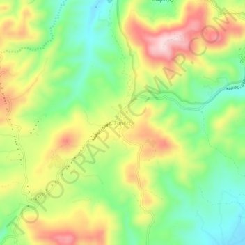
Name: Σαρδές topographic map, elevation, terrain.
Average elevation: 627 ft
Minimum elevation: 223 ft
Maximum elevation: 1,132 ft
Other topographic maps
Click on a map to view its topography, its elevation and its terrain.
Lemnos
Greece > Aegean > Lemnos Regional Unit
Lemnos, Lemnos Regional Unit, Northern Aegean, Aegean, Greece
Average elevation: 89 ft
Myrina
Greece > Aegean > Lemnos Regional Unit
Myrina, Lemnos Municipality, Lemnos Regional Unit, Northern Aegean, Aegean, 814 00, Greece
Average elevation: 128 ft
Agios Efstratios
Greece > Aegean > Lemnos Regional Unit > Agios Efstratios
Agios Efstratios, Agios Efstratios Municipality, Lemnos Regional Unit, Northern Aegean, Aegean, 815 00, Greece
Average elevation: 125 ft
Athira
Greece > Aegean > Lemnos Regional Unit > Athira
Athira, Lemnos Municipality, Lemnos Regional Unit, Northern Aegean, Aegean, 81401, Greece
Average elevation: 105 ft