
Odell topographic map
Interactive map
Click on the map to display elevation.
About this map
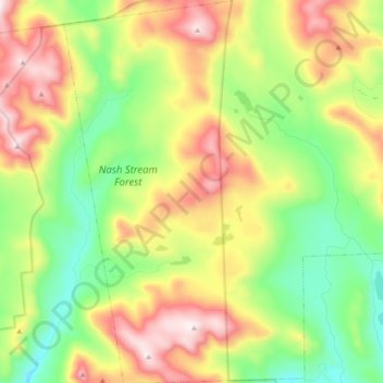
Name: Odell topographic map, elevation, terrain.
Location: Odell, Coös County, New Hampshire, United States (44.65996 -71.44437 44.79573 -71.32428)
Average elevation: 2,208 ft
Minimum elevation: 1,207 ft
Maximum elevation: 3,655 ft
A substantial portion of the state-owned Nash Stream Forest lies within the township. There are three mountains, each having elevations above 3,000 feet (910 m): Muise Mountain, Whitcomb Mountain and Long Mountain, whose two summits are the two highest points in Odell, at 3,661 feet (1,116 m) above sea level each. There are only a few rough roads and no highways here.