
Sulingen topographic map
Interactive map
Click on the map to display elevation.
About this map
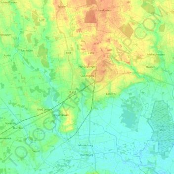
Name: Sulingen topographic map, elevation, terrain.
Location: Sulingen, Landkreis Diepholz, Lower Saxony, 27232, Germany (52.61733 8.65793 52.72997 8.89059)
Average elevation: 144 ft
Minimum elevation: 102 ft
Maximum elevation: 213 ft
Other topographic maps
Click on a map to view its topography, its elevation and its terrain.
Barnstorf
Germany > Lower Saxony > Landkreis Diepholz
Barnstorf, Samtgemeinde Barnstorf, Landkreis Diepholz, Lower Saxony, Germany
Average elevation: 125 ft
Drebber
Germany > Lower Saxony > Landkreis Diepholz > Drebber
Drebber, Samtgemeinde Barnstorf, Landkreis Diepholz, Lower Saxony, 49457, Germany
Average elevation: 125 ft
Brockum
Germany > Lower Saxony > Landkreis Diepholz
Brockum, Samtgemeinde Altes Amt Lemförde, Landkreis Diepholz, Lower Saxony, Germany
Average elevation: 154 ft
Syke
Germany > Lower Saxony > Landkreis Diepholz
Syke, Landkreis Diepholz, Lower Saxony, 28857, Germany
Average elevation: 108 ft