Geolocate

Knapp topographic map

Click on the map to display elevation.

About this map

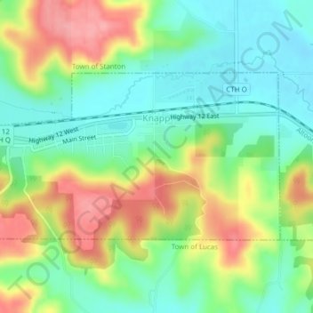
Name: Knapp topographic map, elevation, terrain.

Location: Knapp, Dunn County, Wisconsin, United States (44.94468 -92.09589 44.95915 -92.06034)

Average elevation: 1,020 ft

Minimum elevation: 889 ft

Maximum elevation: 1,217 ft

Dunn County trails, hiking, mountain biking, running and outdoor activities

Other topographic maps

Click on a map to view its topography, its elevation and its terrain.

Cedar Falls

United States > Wisconsin > Dunn County

Average elevation: 899 ft

Mount Fuji

United States > Wisconsin > Dunn County

Average elevation: 1,027 ft

Mount Fuji

United States > Wisconsin > Dunn County

Average elevation: 1,027 ft

Graytown

United States > Wisconsin > Dunn County

Average elevation: 1,129 ft

Canary Island

United States > Wisconsin > Dunn County > Menomonie

Average elevation: 860 ft

Gear up for your next adventure:

🔦LED Headlamp - Bright and durable LED headlamp for night navigation
📚Navigation Handbooks - Master the art of reading topographic maps and using a compass
🧭Compass with Lanyard - Easy‑carry compass for navigation
🛏️Cold Weather Sleeping Bag - Warm sleeping bag for cold conditions
🧥Men's Rain Shells - Premium waterproof and breathable jackets for mountain weather

As an Amazon Associate, this site earns from qualifying purchases at no extra cost to you.