
Make a donation
Gear up for your next adventure:
As an Amazon Associate, this site earns from qualifying purchases at no extra cost to you.
Skudai topographic map
Click on the map to display elevation.
Make a donation
Gear up for your next adventure:
As an Amazon Associate, this site earns from qualifying purchases at no extra cost to you.
About this map
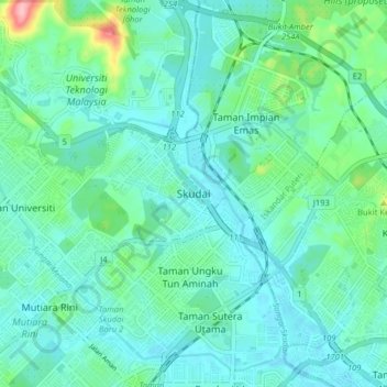
Name: Skudai topographic map, elevation, terrain.
Location: Skudai, Iskandar Puteri, Johor Bahru, Johor, 81210, Malaysia (1.49697 103.62210 1.57697 103.70210)
Average elevation: 95 ft
Minimum elevation: 7 ft
Maximum elevation: 489 ft
Make a donation
Gear up for your next adventure:
As an Amazon Associate, this site earns from qualifying purchases at no extra cost to you.
Other topographic maps
Click on a map to view its topography, its elevation and its terrain.
Make a donation
Gear up for your next adventure:
As an Amazon Associate, this site earns from qualifying purchases at no extra cost to you.
Make a donation
Gear up for your next adventure:
As an Amazon Associate, this site earns from qualifying purchases at no extra cost to you.
Make a donation
Gear up for your next adventure:
As an Amazon Associate, this site earns from qualifying purchases at no extra cost to you.
Bandar Gelang Patah
Malaysia > Johor > Iskandar Puteri > Gelang Patah > Bandar Gelang Patah
Average elevation: 36 ft