
Make a donation
Gear up for your next adventure:
As an Amazon Associate, this site earns from qualifying purchases at no extra cost to you.
Quíbor topographic map
Click on the map to display elevation.
Make a donation
Gear up for your next adventure:
As an Amazon Associate, this site earns from qualifying purchases at no extra cost to you.
Quíbor
Ubicada en la depresión del Valle de Quíbor en el centro occidental del país en el estado Lara. Está prácticamente unida con la ciudad de Barquisimeto, la capital del estado. La población de Quíbor se sitúa a una altitud de 700 metros sobre el nivel del mar. Sus coordenadas son Latitud 9º55'41" N, longitud 69º34'40" O.
Make a donation
Gear up for your next adventure:
As an Amazon Associate, this site earns from qualifying purchases at no extra cost to you.
About this map
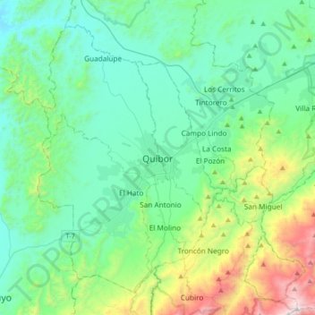
Name: Quíbor topographic map, elevation, terrain.
Average elevation: 2,828 ft
Minimum elevation: 1,673 ft
Maximum elevation: 7,320 ft
Make a donation
Gear up for your next adventure:
As an Amazon Associate, this site earns from qualifying purchases at no extra cost to you.
Other topographic maps
Click on a map to view its topography, its elevation and its terrain.
Parroquia Juan Bautista Rodríguez
Venezuela > Estado Lara > Municipio Jiménez
Average elevation: 2,267 ft