
Peterberg topographic map
Interactive map
Click on the map to display elevation.
About this map
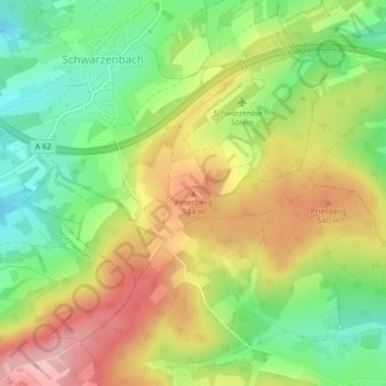
Name: Peterberg topographic map, elevation, terrain.
Average elevation: 1,608 ft
Minimum elevation: 1,342 ft
Maximum elevation: 1,913 ft
Other topographic maps
Click on a map to view its topography, its elevation and its terrain.
Diegelsberg
Deutschland > Saarland > Nohfelden
Diegelsberg, Nohfelden, Landkreis St. Wendel, Saarland, Deutschland
Average elevation: 1,539 ft
Sötern
Deutschland > Saarland > Nohfelden
Sötern, Nohfelden, Landkreis St. Wendel, Saarland, Deutschland
Average elevation: 1,578 ft
Türkismühle
Deutschland > Saarland > Nohfelden
Türkismühle, Nohfelden, Landkreis St. Wendel, Saarland, Deutschland
Average elevation: 1,355 ft