
Benlhevai topographic map
Interactive map
Click on the map to display elevation.
About this map
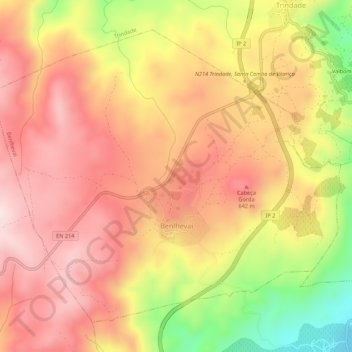
Name: Benlhevai topographic map, elevation, terrain.
Location: Benlhevai, Vila Flor, Distrito de Bragança, Portugal (41.36381 -7.11782 41.39772 -7.06350)
Average elevation: 1,772 ft
Minimum elevation: 866 ft
Maximum elevation: 2,329 ft
Other topographic maps
Click on a map to view its topography, its elevation and its terrain.
Albufeira de Foz Tua Cota 170 Zonas Provaveis de Inundação Troço 5
Portugal > Distrito de Bragança > Vila Flor > Freixiel
Albufeira de Foz Tua Cota 170 Zonas Provaveis de Inundação Troço 5, Freixiel, Vila Flor, Murça, Distrito de Bragança, Portugal
Average elevation: 1,184 ft