
Phooliya Kalan Tehsil topographic map
Interactive map
Click on the map to display elevation.
About this map
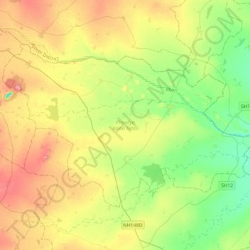
Name: Phooliya Kalan Tehsil topographic map, elevation, terrain.
Location: Phooliya Kalan Tehsil, Bhilwara District, Rajasthan, India (25.69206 74.72986 25.89781 75.07775)
Average elevation: 1,227 ft
Minimum elevation: 1,102 ft
Maximum elevation: 1,394 ft
Other topographic maps
Click on a map to view its topography, its elevation and its terrain.
Brindawan
India > Rajasthan > Beejoliya Tehsil
Brindawan, Beejoliya Tehsil, Bhilwara, Rajasthan, India
Average elevation: 1,604 ft
Aravalli Range
Aravalli Range, Abu Road Tehsil, Sirohi, Rajasthan, 307501, India
Average elevation: 4,393 ft
Guru Shikhar, Abu
Guru Shikhar, Abu, Abu Road Tehsil, Sirohi, Rajasthan, 307501, India
Average elevation: 4,482 ft