
Río Uruguay topographic map
Interactive map
Click on the map to display elevation.
About this map
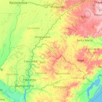
Name: Río Uruguay topographic map, elevation, terrain.
Average elevation: 420 ft
Minimum elevation: -7 ft
Maximum elevation: 2,858 ft
Other topographic maps
Click on a map to view its topography, its elevation and its terrain.
Santo Tomé
Argentina > Corrientes > Santo Tomé
Santo Tomé, Municipio de Santo Tomé, Departamento Santo Tomé, Corrientes, 3340, Argentina
Average elevation: 220 ft