
Stegelitz topographic map
Interactive map
Click on the map to display elevation.
About this map
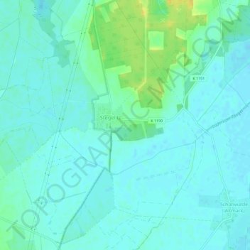
Name: Stegelitz topographic map, elevation, terrain.
Location: Stegelitz, Tangerhütte, Stendal, Sachsen-Anhalt, Deutschland (52.45831 11.74839 52.49288 11.78700)
Average elevation: 131 ft
Minimum elevation: 112 ft
Maximum elevation: 187 ft
Other topographic maps
Click on a map to view its topography, its elevation and its terrain.
Groß Schwarzlosen
Deutschland > Sachsen-Anhalt > Tangerhütte
Groß Schwarzlosen, Tangerhütte, Stendal, Sachsen-Anhalt, Deutschland
Average elevation: 171 ft
Weißewarte
Deutschland > Sachsen-Anhalt > Tangerhütte > Weißewarte
Weißewarte, Tangerhütte, Stendal, Sachsen-Anhalt, Deutschland
Average elevation: 121 ft
Kehnert
Deutschland > Sachsen-Anhalt > Tangerhütte
Kehnert, Tangerhütte, Stendal, Sachsen-Anhalt, Deutschland
Average elevation: 141 ft