
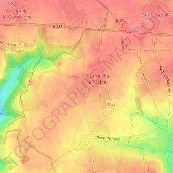
Touffreville-la-Cable topographic map
Interactive map
Click on the map to display elevation.
About this map
Name: Touffreville-la-Cable topographic map, elevation, terrain.
Average elevation: 440 ft
Minimum elevation: 246 ft
Maximum elevation: 505 ft
Other topographic maps
Click on a map to view its topography, its elevation and its terrain.
Triquerville
France > Normandie > Seine-Maritime > Port-Jérôme-sur-Seine
Triquerville, Port-Jérôme-sur-Seine, Le Havre, Seine-Maritime, Normandie, France métropolitaine, 76170, France
Average elevation: 377 ft
Notre-Dame-de-Gravenchon
France > Normandie > Seine-Maritime > Port-Jérôme-sur-Seine
Notre-Dame-de-Gravenchon, Port-Jérôme-sur-Seine, Le Havre, Seine-Maritime, Normandie, France métropolitaine, 76330, France
Average elevation: 138 ft