
Landenberg topographic map
Interactive map
Click on the map to display elevation.
About this map
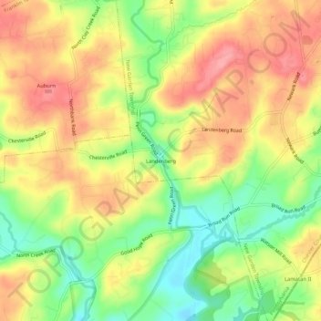
Name: Landenberg topographic map, elevation, terrain.
Average elevation: 315 ft
Minimum elevation: 138 ft
Maximum elevation: 466 ft
Other topographic maps
Click on a map to view its topography, its elevation and its terrain.
Toughkenamon
United States > Pennsylvania > Chester County > New Garden Township
Toughkenamon, New Garden Township, Chester County, Pennsylvania, 19374, United States
Average elevation: 377 ft
Kaolin
United States > Pennsylvania > Chester County > New Garden Township
Kaolin, New Garden Township, Chester County, Pennsylvania, 19311, United States
Average elevation: 354 ft