
Cantù topographic map
Interactive map
Click on the map to display elevation.
About this map
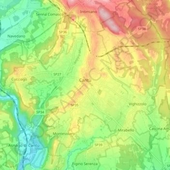
Name: Cantù topographic map, elevation, terrain.
Location: Cantù, Como, Lombardy, 22063, Italy (45.70751 9.09506 45.76796 9.17333)
Average elevation: 1,083 ft
Minimum elevation: 791 ft
Maximum elevation: 1,450 ft
Other topographic maps
Click on a map to view its topography, its elevation and its terrain.
Vighizzolo
Italy > Lombardy > Cantù > Vighizzolo
Vighizzolo, Cantù, Como, Lombardy, 22063, Italy
Average elevation: 1,102 ft