
Make a donation
Gear up for your next adventure:
As an Amazon Associate, this site earns from qualifying purchases at no extra cost to you.
Öhringen topographic map
Click on the map to display elevation.
Make a donation
Gear up for your next adventure:
As an Amazon Associate, this site earns from qualifying purchases at no extra cost to you.
Öhringen
Öhringen is located in the western, deeper part of the Hohenlohe plain, between the Keuper stage of the Swabian-Franconian Forest and the Kocher valley. The town spreads out over the flat valley of the Ohrn, a small river, which flows about 10 kilometres (6 mi) down the valley in the district Ohrnberg into the Kocher river. The town is situated between elevation 168 metres (551 ft), in the Kocher at the county border at Möglingen, and 486 m (1,594 ft), already above the forest on the Charles Mainhardt Furter plane, which belongs to the district Michelbach. The height of the town itself varies between 215–280 metres (705–919 ft).
Make a donation
Gear up for your next adventure:
As an Amazon Associate, this site earns from qualifying purchases at no extra cost to you.
About this map
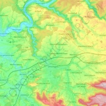
Name: Öhringen topographic map, elevation, terrain.
Average elevation: 925 ft
Minimum elevation: 551 ft
Maximum elevation: 1,598 ft
Make a donation
Gear up for your next adventure:
As an Amazon Associate, this site earns from qualifying purchases at no extra cost to you.
Other topographic maps
Click on a map to view its topography, its elevation and its terrain.