Geolocate

Pooler topographic map

Click on the map to display elevation.

About this map

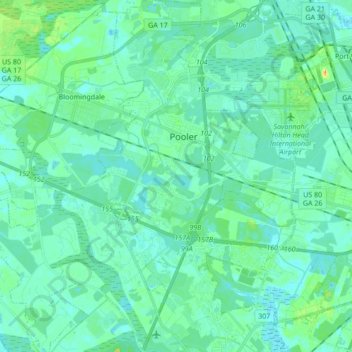
Name: Pooler topographic map, elevation, terrain.

Location: Pooler, Chatham County, Georgia, 31322, United States (32.02745 -81.31156 32.17211 -81.19529)

Average elevation: 23 ft

Minimum elevation: -13 ft

Maximum elevation: 115 ft

Chatham County trails, hiking, mountain biking, running and outdoor activities

Other topographic maps

Click on a map to view its topography, its elevation and its terrain.

Skidaway Island

United States > Georgia > Chatham County

Average elevation: 26 ft

Rio Vista

United States > Georgia > Chatham County

Average elevation: 10 ft

Tremont Park

United States > Georgia > Chatham County > Savannah

Average elevation: 23 ft

Oakdale

United States > Georgia > Chatham County > Savannah

Average elevation: 33 ft

O'Leary

United States > Georgia > Chatham County > Port Wentworth

Average elevation: 16 ft

Welwood

United States > Georgia > Chatham County > Savannah

Average elevation: 23 ft

Gear up for your next adventure:

🧭Outdoor Navigation Book - Learn advanced navigation skills
🥾Men's Hiking Boots - Durable, waterproof footwear for rugged terrain and steep inclines
🕶️Glacier Sunglasses - Side shields to protect eyes from high-altitude snow glare
🪶Multi‑Purpose Knife - Useful blade for camp and trail
🦶Carbon Trekking Poles - Reduce knee impact on steep descents with ultra-light poles

As an Amazon Associate, this site earns from qualifying purchases at no extra cost to you.