
Ward 6 topographic map
Click on the map to display elevation.
About this map
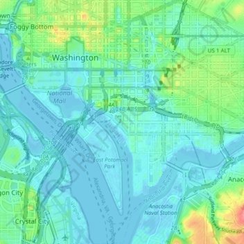
Name: Ward 6 topographic map, elevation, terrain.
Location: Ward 6, Washington, District of Columbia, United States (38.84977 -77.04380 38.90894 -76.97082)
Average elevation: 46 ft
Minimum elevation: -10 ft
Maximum elevation: 233 ft
District of Columbia trails, hiking, mountain biking, running and outdoor activities
Other topographic maps
Click on a map to view its topography, its elevation and its terrain.
United States National Arboretum
United States > District of Columbia > Washington
Average elevation: 69 ft
United States National Arboretum
United States > District of Columbia > Washington
Average elevation: 69 ft