Geolocate

Amirli topographic map

Click on the map to display elevation.

About this map

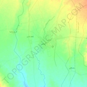
Name: Amirli topographic map, elevation, terrain.

Location: Amirli, Amirli District, Saladin Governorate, Iraq (34.68543 44.54354 34.76543 44.62354)

Average elevation: 571 ft

Minimum elevation: 522 ft

Maximum elevation: 633 ft

Other topographic maps

Click on a map to view its topography, its elevation and its terrain.

Makhool Mountin

Iraq > Saladin Governorate

Average elevation: 627 ft

Baiji

Iraq > Saladin Governorate

Average elevation: 381 ft

Gear up for your next adventure:

🔥Plasma Lighters - Windproof lighters that work in any weather condition
🔥Fast-Boil Camping Stoves - Efficient cooking systems for quick trail meals
🔊Portable Camp Speaker - Music and alerts at camp
🪶Paracord Bracelet - Survival bracelet with built‑in tools
🪶Trail Camera - Capture wildlife on your hikes

As an Amazon Associate, this site earns from qualifying purchases at no extra cost to you.