
Province de Fianarantsoa topographic map
Interactive map
Click on the map to display elevation.
About this map
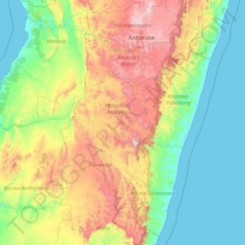
Name: Province de Fianarantsoa topographic map, elevation, terrain.
Location: Province de Fianarantsoa, Madagascar (-24.30325 44.05457 -19.18325 49.17457)
Average elevation: 1,581 ft
Minimum elevation: -3 ft
Maximum elevation: 8,619 ft
Other topographic maps
Click on a map to view its topography, its elevation and its terrain.
Province de Fianarantsoa
Madagascar > Province de Fianarantsoa
Province de Fianarantsoa, Madagascar
Average elevation: 1,480 ft