
Thank you for supporting this site ❤️
Make a donation
Make a donation
Gear up for your next adventure:
As an Amazon Associate, this site earns from qualifying purchases at no extra cost to you.
Bastia topographic map
Click on the map to display elevation.
Thank you for supporting this site ❤️
Make a donation
Make a donation
Gear up for your next adventure:
As an Amazon Associate, this site earns from qualifying purchases at no extra cost to you.
About this map
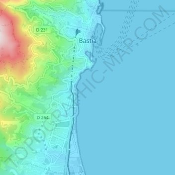
Name: Bastia topographic map, elevation, terrain.
Location: Bastia, Upper Corsica, Corsica, Metropolitan France, France (42.66121 9.39017 42.71089 9.45765)
Average elevation: 220 ft
Minimum elevation: -10 ft
Maximum elevation: 1,762 ft
Thank you for supporting this site ❤️
Make a donation
Make a donation
Gear up for your next adventure:
As an Amazon Associate, this site earns from qualifying purchases at no extra cost to you.