
Isla del Carmen topographic map
Interactive map
Click on the map to display elevation.
About this map
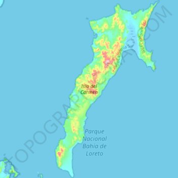
Name: Isla del Carmen topographic map, elevation, terrain.
Location: Isla del Carmen, Loreto, Baja California Sur, México (25.80615 -111.23290 26.07238 -111.05909)
Average elevation: 56 ft
Minimum elevation: -13 ft
Maximum elevation: 1,509 ft
Other topographic maps
Click on a map to view its topography, its elevation and its terrain.