
Hall in Tirol topographic map
Interactive map
Click on the map to display elevation.
About this map
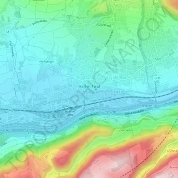
Name: Hall in Tirol topographic map, elevation, terrain.
Location: Hall in Tirol, Bezirk Innsbruck-Land, Oostenrijk (47.27096 11.47248 47.29125 11.52874)
Average elevation: 2,126 ft
Minimum elevation: 1,814 ft
Maximum elevation: 2,986 ft
Other topographic maps
Click on a map to view its topography, its elevation and its terrain.
Padaun
Oostenrijk > Bezirk Innsbruck-Land
Padaun, Vals, Bezirk Innsbruck-Land, 6154, Oostenrijk
Average elevation: 5,423 ft
Trins
Oostenrijk > Bezirk Innsbruck-Land
Trins, Bezirk Innsbruck-Land, 6152, Oostenrijk
Average elevation: 5,597 ft
Milders
Oostenrijk > Bezirk Innsbruck-Land > Neustift im Stubaital
Milders, Neustift im Stubaital, Bezirk Innsbruck-Land, 6167, Oostenrijk
Average elevation: 4,751 ft
Seefeld in Tirol
Oostenrijk > Bezirk Innsbruck-Land
Seefeld in Tirol, Bezirk Innsbruck-Land, 6100, Oostenrijk
Average elevation: 4,275 ft