
Roccapina topographic map
Interactive map
Click on the map to display elevation.
About this map
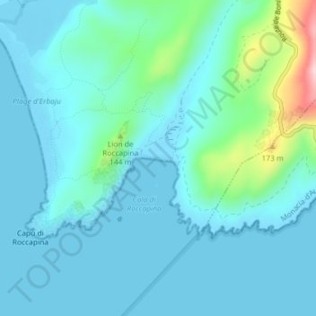
Name: Roccapina topographic map, elevation, terrain.
Average elevation: 121 ft
Minimum elevation: -7 ft
Maximum elevation: 801 ft
Other topographic maps
Click on a map to view its topography, its elevation and its terrain.
Plage Fur
France > Corse > Pianottoli-Caldarello
Plage Fur, T 40, Pianottoli-Caldarello, Sartène, Corse-du-Sud, Corse, France métropolitaine, 20131, France
Average elevation: 89 ft