
Nantou City topographic map
Interactive map
Click on the map to display elevation.
About this map
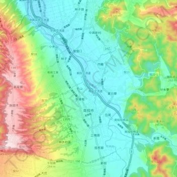
Name: Nantou City topographic map, elevation, terrain.
Location: Nantou City, Nantou County, Taiwan (23.87859 120.62694 23.96546 120.73487)
Average elevation: 630 ft
Minimum elevation: 240 ft
Maximum elevation: 1,447 ft
Other topographic maps
Click on a map to view its topography, its elevation and its terrain.
Biluxi
Taiwan > Nantou County > Renai Township
Biluxi, Rongxing Village, Renai Township, Nantou County, Taiwan
Average elevation: 7,723 ft
Xinyi Township
Xinyi Township, Nantou County, Taiwan
Average elevation: 4,360 ft