
Den Burg topographic map
Interactive map
Click on the map to display elevation.
About this map
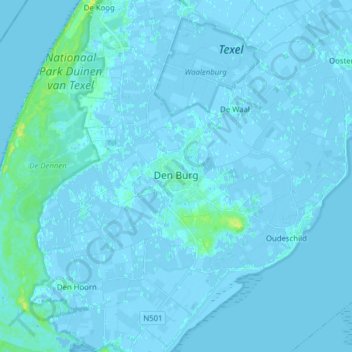
Name: Den Burg topographic map, elevation, terrain.
Location: Den Burg, Texel, Nordholland, Niederlande (53.02949 4.68635 53.08025 4.84236)
Average elevation: 3 ft
Minimum elevation: -13 ft
Maximum elevation: 52 ft
Other topographic maps
Click on a map to view its topography, its elevation and its terrain.
De Koog
Niederlande > Nordholland > Texel
De Koog, Texel, Nordholland, Niederlande
Average elevation: 3 ft
Oosterend
Niederlande > Nordholland > Texel
Oosterend, Texel, Nordholland, Niederlande
Average elevation: 0 ft