
Palihan topographic map
Interactive map
Click on the map to display elevation.
About this map
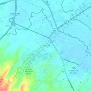
Name: Palihan topographic map, elevation, terrain.
Average elevation: 49 ft
Minimum elevation: 16 ft
Maximum elevation: 236 ft
Other topographic maps
Click on a map to view its topography, its elevation and its terrain.
Balsik
Philippines > Bataan > Hermosa
Balsik, Hermosa, Bataan, Central Luzon, 2111, Philippines
Average elevation: 30 ft
Maite
Philippines > Bataan > Hermosa
Maite, Hermosa, Bataan, Central Luzon, 2111, Philippines
Average elevation: 207 ft