
Village of Ellenville topographic map
Interactive map
Click on the map to display elevation.
About this map
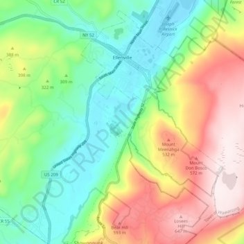
Name: Village of Ellenville topographic map, elevation, terrain.
Average elevation: 1,066 ft
Minimum elevation: 279 ft
Maximum elevation: 2,283 ft
Other topographic maps
Click on a map to view its topography, its elevation and its terrain.
Sam's Point Overlook
United States > New York > Ulster County > Town of Wawarsing > Village of Ellenville
Sam's Point Overlook, Loop Road, Village of Ellenville, Town of Wawarsing, Ulster County, New York, 12420, United States
Average elevation: 1,778 ft
Bear Hill Preserve (Cragsmoor Free Library)
United States > New York > Ulster County > Town of Wawarsing > Cragsmoor
Bear Hill Preserve (Cragsmoor Free Library), Route 52, Cragsmoor, Town of Wawarsing, Town of Shawangunk, Ulster County, New York, 12428, United States
Average elevation: 1,358 ft
Sholam
United States > New York > Ulster County > Town of Wawarsing
Sholam, Town of Wawarsing, Ulster County, New York, 12458, United States
Average elevation: 1,257 ft
Napanoch
United States > New York > Ulster County > Town of Wawarsing
Napanoch, Town of Wawarsing, Ulster County, New York, United States
Average elevation: 479 ft
Greenfield Park
United States > New York > Ulster County > Town of Wawarsing
Greenfield Park, Town of Wawarsing, Ulster County, New York, 12435, United States
Average elevation: 1,086 ft
Kerhonkson
United States > New York > Ulster County > Town of Wawarsing
Kerhonkson, Town of Wawarsing, Ulster County, New York, United States
Average elevation: 548 ft