Geolocate

Vimy topographic map

Click on the map to display elevation.

About this map

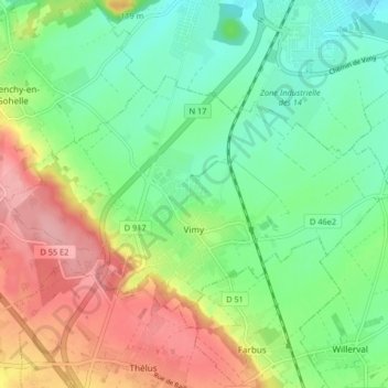
Name: Vimy topographic map, elevation, terrain.

Location: Vimy, Lens, Pas-de-Calais, Hauts-de-France, Metropolitan France, 62580, France (50.36209 2.77143 50.39403 2.85349)

Average elevation: 262 ft

Minimum elevation: 112 ft

Maximum elevation: 495 ft

Other topographic maps

Click on a map to view its topography, its elevation and its terrain.

Entre Deux Chemins

France > Hauts-de-France > Pas-de-Calais > Herly

Average elevation: 558 ft

Le Petit Vimy

France > Hauts-de-France > Pas-de-Calais > Vimy

Average elevation: 305 ft

Noyelles

France > Hauts-de-France > Pas-de-Calais > Bours

Average elevation: 410 ft

Mont Pourri

France > Hauts-de-France > Pas-de-Calais > Saint-Aubin

Average elevation: 105 ft

Gear up for your next adventure:

🎒Gear Packing Cubes - Organize your backpack efficiently
🛌Ultralight Sleeping Bags - Compact down bags for cold nights in the wilderness
🛏️Cold Weather Sleeping Bag - Warm sleeping bag for cold conditions
🧦Hiking Socks - Comfortable socks to prevent blisters on long hikes
🧴Hand Sanitizer - Keep hands clean while hiking

As an Amazon Associate, this site earns from qualifying purchases at no extra cost to you.