
Schwamendingen topographic map
Interactive map
Click on the map to display elevation.
About this map
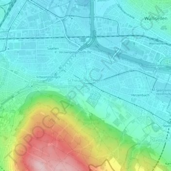
Name: Schwamendingen topographic map, elevation, terrain.
Location: Schwamendingen, Zürich, Bezirk Zürich, Zürich, 8051, Schweiz (47.38789 8.55351 47.42004 8.59728)
Average elevation: 1,568 ft
Minimum elevation: 1,375 ft
Maximum elevation: 2,192 ft
Other topographic maps
Click on a map to view its topography, its elevation and its terrain.
Wollishofen
Wollishofen, Kreis 2, Zürich, Bezirk Zürich, Zürich, 8038, Schweiz
Average elevation: 1,463 ft
Aussersihl
Aussersihl, Zürich, Bezirk Zürich, Zürich, Schweiz
Average elevation: 1,371 ft
Industriequartier
Industriequartier, Zürich, Bezirk Zürich, Zürich, 8005, Schweiz
Average elevation: 1,404 ft