
Sarangani topographic map
Interactive map
Click on the map to display elevation.
About this map
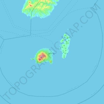
Name: Sarangani topographic map, elevation, terrain.
Location: Sarangani, Davao Occidental, Davao Region, Philippines (5.22969 125.19475 5.60559 125.63527)
Average elevation: 43 ft
Minimum elevation: -3 ft
Maximum elevation: 2,707 ft
Other topographic maps
Click on a map to view its topography, its elevation and its terrain.
Balut Island
Philippines > Davao Occidental > Sarangani
Balut Island, Sarangani, Davao Occidental, Davao Region, 8015, Philippines
Average elevation: 285 ft