Geolocate

Maasin topographic map

Click on the map to display elevation.

About this map

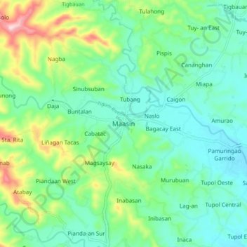
Name: Maasin topographic map, elevation, terrain.

Location: Maasin, Iloilo, Western Visayas, Philippines (10.85082 122.39328 10.93082 122.47328)

Average elevation: 410 ft

Minimum elevation: 157 ft

Maximum elevation: 1,096 ft

Other topographic maps

Click on a map to view its topography, its elevation and its terrain.

Balasan

Philippines > Iloilo

Average elevation: 138 ft

Banate

Philippines > Iloilo

Average elevation: 112 ft

Miagao

Philippines > Iloilo

Average elevation: 318 ft

Lambunao

Philippines > Iloilo > Lambunao

Average elevation: 417 ft

Anilao

Philippines > Iloilo > Anilao

Average elevation: 171 ft

Bayas Island

Philippines > Iloilo > Estancia > Bayas

Average elevation: 3 ft

Balbagon Island

Philippines > Iloilo > Carles

Average elevation: 0 ft

Leganes

Philippines > Iloilo

Average elevation: 26 ft

Gear up for your next adventure:

🎁Geography Themed Gifts - Unique gift ideas for map lovers and geography enthusiasts
☀️Outdoor Sunscreen - High protection sunscreen for outdoor activities
🪶Camp Gear Gift Set - Perfect gift bundle for outdoor fans
🚑Emergency Bivvies - Heat-reflective sleeping bags for survival situations
🛡️Insect Repellent - Protection against bugs during outdoor activities

As an Amazon Associate, this site earns from qualifying purchases at no extra cost to you.