
Koratty topographic map
Interactive map
Click on the map to display elevation.
About this map
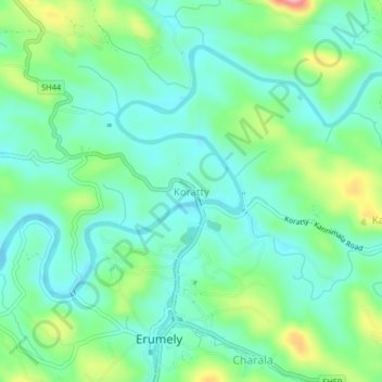
Name: Koratty topographic map, elevation, terrain.
Location: Koratty, Kanjirappally, Kottayam, Kerala, 686509, India (9.47679 76.82832 9.51679 76.86832)
Average elevation: 246 ft
Minimum elevation: 115 ft
Maximum elevation: 591 ft
Other topographic maps
Click on a map to view its topography, its elevation and its terrain.
Bhoothakulam
India > Kerala > Kanjirappally > Panamattam
Bhoothakulam, Panamattam, Kanjirappally, Kottayam District, Kerala, India
Average elevation: 397 ft
Manimala
India > Kerala > Kanjirappally
Manimala, Kanjirappally, Kottayam, Kerala, 686543, India
Average elevation: 213 ft
Mukkoottuthara
India > Kerala > Kanjirappally
Mukkoottuthara, Kanjirappally, Kottayam, Kerala, 686510, India
Average elevation: 522 ft
Kanjirappalli
India > Kerala > Kanjirappally
Kanjirappalli, Kanjirappally, Kottayam, Kerala, 686507, India
Average elevation: 272 ft
Chenappady
India > Kerala > Kanjirappally > Chenappady
Chenappady, Kanjirappally, Kottayam, Kerala, 686520, India
Average elevation: 210 ft
Erumely
India > Kerala > Kanjirappally
Erumely, Kanjirappally, Kottayam, Kerala, 686509, India
Average elevation: 335 ft