
Nyingchi topographic map
Interactive map
Click on the map to display elevation.
About this map
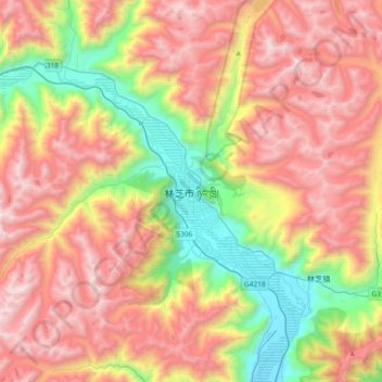
Name: Nyingchi topographic map, elevation, terrain.
Average elevation: 13,238 ft
Minimum elevation: 9,629 ft
Maximum elevation: 16,890 ft
The average elevation of Nyingchi is 3,040 meters (9,974 feet), which is the lowest compared with the other prefectures in Tibet. So, the risk of getting high-altitude sickness is relatively lower than other parts on the plateau. Guangdong province announced in 2012 that it plans to invest more than RMB 400 million (US$63 million) in Nyingchi's tourism industry. According to the plan, Guangdong will help build 22 "prosperous model villages" in Nyingchi in counties such as Bomê and Zayü.