
Make a donation
Gear up for your next adventure:
As an Amazon Associate, this site earns from qualifying purchases at no extra cost to you.
Nyingchi topographic map
Click on the map to display elevation.
Make a donation
Gear up for your next adventure:
As an Amazon Associate, this site earns from qualifying purchases at no extra cost to you.
Nyingchi
The average elevation of Nyingchi is 3,040 meters (9,974 feet), which is the lowest compared with the other prefectures in Tibet. So, the risk of getting high-altitude sickness is relatively lower than other parts on the plateau. Guangdong province announced in 2012 that it plans to invest more than RMB 400 million (US$63 million) in Nyingchi's tourism industry. According to the plan, Guangdong will help build 22 "prosperous model villages" in Nyingchi in counties such as Bomê and Zayü.
Make a donation
Gear up for your next adventure:
As an Amazon Associate, this site earns from qualifying purchases at no extra cost to you.
About this map
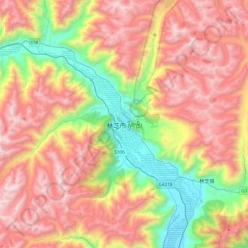
Name: Nyingchi topographic map, elevation, terrain.
Average elevation: 13,238 ft
Minimum elevation: 9,629 ft
Maximum elevation: 16,890 ft
Make a donation
Gear up for your next adventure:
As an Amazon Associate, this site earns from qualifying purchases at no extra cost to you.