
Constantine topographic map
Interactive map
Click on the map to display elevation.
Constantine
Constantine is situated on a plateau at an elevation 640 metres (2,100 ft) above sea level. The city is framed by a deep ravine and has a dramatic appearance. The city is very picturesque with a number of bridges over Rhumel River and a viaduct crossing the ravine. The ravine is crossed by seven bridges, including Sidi M'Cid bridge. Constantine is the railhead of a prosperous and diverse agricultural area. It is also a centre of the grain trade and has flour mills, a tractor factory, and industries producing textiles, wool, linen and leather goods. Algeria and Tunisia serve as its markets.
About this map
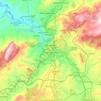
Name: Constantine topographic map, elevation, terrain.
Location: Constantine, Constantine District, Constantine, Algeria (36.25893 6.52845 36.44909 6.76655)
Average elevation: 2,152 ft
Minimum elevation: 961 ft
Maximum elevation: 3,950 ft
Other topographic maps
Click on a map to view its topography, its elevation and its terrain.
Oued Boumerzoug
Algeria > Constantine > Constantine District > Constantine
Average elevation: 2,054 ft
Les Combattants
Algeria > Constantine > Constantine District > Constantine
Average elevation: 1,814 ft