
Îlet à Cordes topographic map
Interactive map
Click on the map to display elevation.
About this map
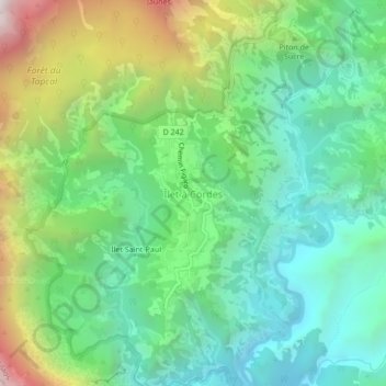
Name: Îlet à Cordes topographic map, elevation, terrain.
Average elevation: 3,566 ft
Minimum elevation: 1,667 ft
Maximum elevation: 7,736 ft
Other topographic maps
Click on a map to view its topography, its elevation and its terrain.
Ilet Saint-Paul
France > La Réunion > Cilaos > Îlet à Cordes
Ilet Saint-Paul, Îlet à Cordes, Cilaos, Saint-Pierre, La Réunion, 97413, France
Average elevation: 3,970 ft