
Make a donation
Gear up for your next adventure:
As an Amazon Associate, this site earns from qualifying purchases at no extra cost to you.
Valledupar topographic map
Click on the map to display elevation.
Make a donation
Gear up for your next adventure:
As an Amazon Associate, this site earns from qualifying purchases at no extra cost to you.
Valledupar
Valledupar is located southeast of the Sierra Nevada de Santa Marta. Its average temperature is 28 °C. Because of its relatively high altitude and proximity to the equator, it has a variety of environments, from warm heat to perpetual snow. Notable geographic features in Valledupar include the Sierra Nevada de Santa Marta's peaks; the Codazzi, El Guardian, the Ojeda and La Reina. Many rivers descend from its snowy peaks and lagoons; the Ariguani, Ariguanicito, Badillo, Calderas, Cesar, Curiba, Donachui, Garupal, Guatapuri, which borders the city of Valledupar; and the Mariangola.
Make a donation
Gear up for your next adventure:
As an Amazon Associate, this site earns from qualifying purchases at no extra cost to you.
About this map
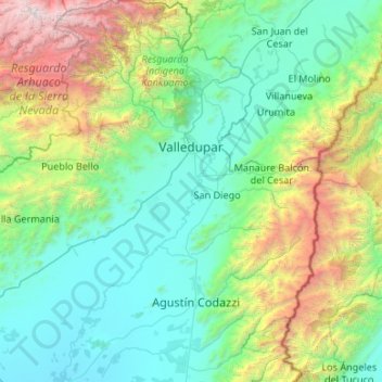
Name: Valledupar topographic map, elevation, terrain.
Location: Valledupar, Cesar, RAP Caribe, Colombia (9.81861 -73.83836 10.86762 -73.07661)
Average elevation: 3,566 ft
Minimum elevation: 151 ft
Maximum elevation: 18,412 ft
Make a donation
Gear up for your next adventure:
As an Amazon Associate, this site earns from qualifying purchases at no extra cost to you.
Other topographic maps
Click on a map to view its topography, its elevation and its terrain.