
Make a donation
Gear up for your next adventure:
As an Amazon Associate, this site earns from qualifying purchases at no extra cost to you.
Predeal topographic map
Click on the map to display elevation.
Make a donation
Gear up for your next adventure:
As an Amazon Associate, this site earns from qualifying purchases at no extra cost to you.
Predeal
Predeal (pronounced [preˈde̯al]; Hungarian: Predeál) is a town in Brașov County, Transylvania, Romania. Predeal, a mountain resort town, is the highest town in Romania. It is located in the Prahova Valley at an elevation of over 1,000 m (3,281 ft).
Make a donation
Gear up for your next adventure:
As an Amazon Associate, this site earns from qualifying purchases at no extra cost to you.
About this map
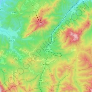
Name: Predeal topographic map, elevation, terrain.
Location: Predeal, Zona Metropolitană Brașov, Brașov, Romania (45.45894 25.50699 45.60584 25.70223)
Average elevation: 3,635 ft
Minimum elevation: 2,008 ft
Maximum elevation: 6,503 ft
Make a donation
Gear up for your next adventure:
As an Amazon Associate, this site earns from qualifying purchases at no extra cost to you.
Other topographic maps
Click on a map to view its topography, its elevation and its terrain.
Make a donation
Gear up for your next adventure:
As an Amazon Associate, this site earns from qualifying purchases at no extra cost to you.