
Baybay topographic map
Interactive map
Click on the map to display elevation.
About this map
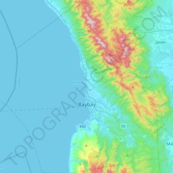
Name: Baybay topographic map, elevation, terrain.
Average elevation: 515 ft
Minimum elevation: 0 ft
Maximum elevation: 3,730 ft
The climate is of Coronas Climate type IV, which is generally wet with no particularly discernible seasons. Its topography is generally mountainous in the eastern portion as it slopes down west towards the shore line. Generally an agricultural city, the common means of livelihood are farming and fishing. Some are engaged in hunting and in forestal activities. The most common crops grown are rice, corn, abaca, root crops, fruits, and vegetables. Various cottage industries can also be found in Baybay such as bamboo and rattan craft, ceramics, dress-making, fiber craft, food preservation, mat weaving, metal craft, furniture manufacture and other related activities.
Other topographic maps
Click on a map to view its topography, its elevation and its terrain.
Pangasugan
Philippines > Leyte > Baybay
Pangasugan, Baybay, 5th District, Leyte, Eastern Visayas, 6521, Philippines
Average elevation: 200 ft
Cabgan Island
Philippines > Leyte > Palompon
Cabgan Island, Palompon, 4th District, Leyte, Eastern Visayas, 6538, Philippines
Average elevation: 0 ft
Kabalasan
Philippines > Leyte > Baybay
Kabalasan, Baybay, 5th District, Leyte, Eastern Visayas, Philippines
Average elevation: 144 ft
Cuta
Philippines > Leyte > Barugo
Cuta, Barugo, 2nd District, Leyte, Eastern Visayas, 6519, Philippines
Average elevation: 23 ft
Mount Magsanga
Philippines > Leyte > Merida
Mount Magsanga, Merida, 4th District, Leyte, Eastern Visayas, 6540, Philippines
Average elevation: 938 ft
Green Valley
Philippines > Leyte > Ormoc
Green Valley, Ormoc, 4th District, Leyte, Eastern Visayas, 6541, Philippines
Average elevation: 266 ft
Patag
Philippines > Leyte > Baybay
Patag, Baybay, 5th District, Leyte, Eastern Visayas, 6521, Philippines
Average elevation: 210 ft
Paglaum
Philippines > Leyte > Carigara
Paglaum, Carigara, Leyte 2nd District, Leyte, Eastern Visayas, 6529, Philippines
Average elevation: 906 ft
Matag-Ob
Matag-Ob, Leyte 4th District, Leyte, Eastern Visayas, 6532, Philippines
Average elevation: 217 ft
Paglocsoon
Philippines > Leyte > Ormoc > Dolores
Paglocsoon, Dolores, Ormoc, Leyte 4th District, Leyte, Eastern Visayas, 6541, Philippines
Average elevation: 1,056 ft
Barugo
Barugo, Leyte 2nd District, Leyte, Eastern Visayas, 6519, Philippines
Average elevation: 39 ft
Hilongos
Hilongos, Leyte 5th District, Leyte, Eastern Visayas, 6524, Philippines
Average elevation: 371 ft
Imelda
Philippines > Leyte > Hilongos
Imelda, Hilongos, Leyte 5th District, Leyte, Eastern Visayas, 6524, Philippines
Average elevation: 161 ft
Palompon
Palompon, Leyte 4th District, Leyte, Eastern Visayas, 6538, Philippines
Average elevation: 102 ft
Sto. Nino
Philippines > Leyte > Mahaplag
Sto. Nino, Mahaplag, Leyte 5th District, Leyte, Eastern Visayas, 6512, Philippines
Average elevation: 571 ft
Cabacungan
Philippines > Leyte > Dulag
Cabacungan, Dulag, Leyte 2nd District, Leyte, Eastern Visayas, 6505, Philippines
Average elevation: 43 ft
San Isidro
Philippines > Leyte > Jaro
San Isidro, Jaro, Leyte 2nd District, Leyte, Eastern Visayas, 6527, Philippines
Average elevation: 187 ft
Sea of Clouds
Philippines > Leyte > Baybay
Sea of Clouds, Abuyog-Baybay City South Road, Baybay, Leyte 5th District, Leyte, Eastern Visayas, 6521, Philippines
Average elevation: 614 ft
Matalom
Matalom, Leyte 5th District, Leyte, Eastern Visayas, 6526, Philippines
Average elevation: 279 ft
Inopacan
Inopacan, Leyte 5th District, Leyte, Eastern Visayas, 6522, Philippines
Average elevation: 371 ft
Uyawan
Philippines > Leyte > Carigara
Uyawan, Carigara, Leyte 2nd District, Leyte, Eastern Visayas, 6529, Philippines
Average elevation: 36 ft
Ormoc
Ormoc, Leyte 4th District, Leyte, Eastern Visayas, 6541, Philippines
Average elevation: 689 ft
Calubian
Philippines > Leyte > Calubian
Calubian, Leyte 3rd District, Leyte, Eastern Visayas, 6534, Philippines
Average elevation: 486 ft
Barangay 62
Philippines > Leyte > Tacloban > Barangay 62
Barangay 62, Tacloban, Leyte, Eastern Visayas, 6500, Philippines
Average elevation: 39 ft